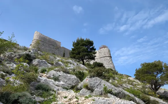
Ponza Grande via north ridge
Route scheme
Trip overview
Group of Ponza peaks makes the border between Slovenia and Italy and separates two valleys - Tamar and Fusine lakes. Starting from north we have Ponza Piccola/Mala Ponca (1921m), Ponza Grande/Visoka Ponca (2274m), Ponza di Mezzo/Srednja Ponza (2230m) and Ponza di Dietro / Zadnja Ponca (2242m). Last three of them are connected by tourist trails and accessible both from Italian and Slovenian side and they make part of the famous Via degli Alpini route. Ponza Piccola is also accessible itself via a tourist trail, however there is no trail connecting it to Ponza Grande.
Route is fairly easily readable with maybe one exception, even with lack of frequent visits like pitons, crampon scratches, warped rock we were able to navigate it as the basic rule is to look for the most manageable passage. Once climbing, the best idea is to look for dwarf pines, they hold the best in this brittle world. Because of that, there is not that much pleasure from climbing itself as every hold and step needs to be checked before using.
Route description
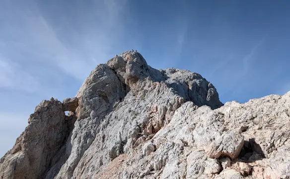
Ponza Grande/Visoka Ponca north ridge (III) access description:
From Fusine lakes big parking lot using trail 512 through Rifugio Luigi Zacchi mountain hut we reach Porticina/ Vratica pass. Optionally, we can also climb Ponza Piccola/ Mala Ponca, the junction is to the left, just below the pass.
Ponza Grande/Visoka Ponca north ridge (III) route description:
Starting from Porticina/ Vratica col we don’t climb the ridge directly but keep on the right (Italian) side. First to the right using shorter right chimney, above it in the direction of the ridge (III grade) leading to another chimney limited on the right by an indistinct tower. From the tower up in the ridge direction on plates with dwarf pine holes. Rock is very brittle.
We land on a short sharp ridge (there are two ridges like that in total), bypass the first culmination on the left and enter the ridge on the second. However here we traversed to the right in the direction of dwarf pines and back on the ridge using a cracked vertical plate (III - might be easier on the ridge). Now directly through the exposed ridge and descending again - leave the ridge on the right side (II grade, brittle, exposed).
Up on the left side of the gully to a small col overlooking a culmination with a prominent larch tree. From here up through initial threshold, keeping to the right in easy scramble with short chimney exit to the left and there walking to the top of this culmination with border stone no 2/136. Careful descent in crumbly terrain but without usage of hands. More walking follows through dwarf pines - indistinct path available.
The next culmination is cut in half with a gully-like formation, we scramble it and then enter the left side to get to the top through grassy shelves. Wide at the start, the ridge gets narrower and exposed again but is technically easy, still needs attention during down-climbing due to brittle rock.
From another tiny col under steep and vertical ridge we traverse to the right first under overhanging rocks then on a narrowing path. Once again in right direction we scramble down to cross central part of the gully running from the top and climb again on pleasant rocky slabs (least brittle stretch overall) to the edge where we can easily see a long gully lying along the ridge line. Up with this gully, exiting it to the left through big rock blocks to the pre-summit of Ponza Grande and climbing 10 meters down in II chimney.
Now through a wider, yet exposed ridge, bypassing first tower on the left, traversing a slab (piton present here) and bypassing another tower on the left again. Pass before a dominant and prominent block to the left (narrow but passable) and up in easier terrain to the first peak of Ponza Grande.
Ponza Grande/Visoka Ponca (2.274m) - via ferrata descent (C):
Ponza Grande/Visoka Ponca is accessible with two marked paths that can be used. One can descend directly from the peak along via ferrata or through Forcella Ponza/Ponca Škrbina (2172 m) pass. Via ferrata is of C difficulty, very crumbly in the first stretches, quite steep, protection is whenever needed. Vertical stretches are aided with metal steps. Once descended from the Great Ponza east face it meanders around the gully (there might be patches of snow, ice axes were absolutely necessary in May) and then lands on the path between dwarf pines and takes us to Rifugio Luigi Zacchi mountain hut. From there using trail 512 back to the parking lot.
Trip conditions
Weather:
Around 9 degrees, changeable weather with low hanging clouds and perceivable cold when hidden in shade, then on the ridge in the sun definitely too hot for long sleeve.
Trail:
Ridge route is not marked, rock on the ridge is brittle, don't want to exaggerate but in places it is even very brittle. On the bright side I want to emphasize there are also spots with better rock quality (partly Ponza Grande pre-summit stretch). Generally you should be familiar with limestone rock and ideally experienced in the field. There are barely any indications in the rock or grass about route so that won't help to navigate, but that's not a big issue as following the most manageable passage works fine.
Ascent and descent trails are well marked, accessible and well-trodden. Top part of descent via ferrata runs through crumbly terrain, extreme caution is needed if there are other people above/below. Top part of via ferrata was renovated lately and looks brand new in places.
Additional information
Tips and author's comments:
This ridge is mostly no pleasant climbing, every step and hold must be checked twice due to brittle rock. We referred to it as dwarf pine route as these small trees are the only firm points in case protection is needed. We agreed that it isn't technically difficult but having no protection would be a gamble game. We used simul climbing with 15-20 meters of rope distance between us. What makes this ridge worthwhile is the wilderness it comes with - there are hardly any pitons or marks left by other climbers.
Original description of the route mentions time of 2 to 3 hours and that time might be doable in free soloing only in my opinion.
If you are interested in doing more via ferrata activity (Italiana or Della Vita routes) in the area of Fusine lakes check out Mangart post.
Links:Route descriptionSpot with better rock qualityMangart from Fusine lakes
Dangers:
Brittle rock is the biggest safety problem both for the lead climber and second climber. That goes for the ridge, for the descent it's also the main issue in the first meters of via ferrata descent.
Gear used:
ascent shoes, trekking poles, 30l rucksack, 2x30m twin rope, helmet, personal climbing set, 5 loops, friends 0.5-2, 5 stoppers, 10m accessory cord for emergency rappelling
Transportation:
Starting point reached by car. There's a huge parking lot above both Fusine lakes, there is also option to park along the road or even before them (more shades). There is a toll for using the road and parking - 6 EUR, however only in high season.
Links:Parking location