Triglav via Plemenice
Route scheme
Trip overview
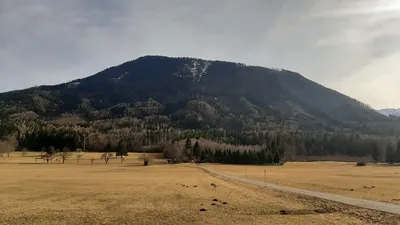
Triglav is the highest mountain in Slovenia, standing at 2,864 meters, and is a prominent symbol of the country, featured on the national coat of arms and flag. Located in the Julian Alps, it is a popular destination for hikers and climbers, offering challenging routes and breathtaking views. The mountain holds significant cultural and historical importance, often regarded as a national symbol of pride and identity for Slovenians.
Route description
Triglav via Plemenice (II/C) - route description:
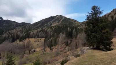
Čez Plemenice (or Bambergova pot) is one among many marked trails that take us to the peak of Triglav and is considered to be the most demanding. It starts from Luknja pass and leads up through the western slopes of Plemenice peak. It's a pretty steep climb from the start, part of it is a classical via ferrata, however most of the trail is unprotected. There are maybe two sections that require more attention as they are exposed (and maybe thus rated II climbing difficulty), the rest is a really enjoyable scramble and hike.
As already mentioned, čez Plemenice is the most challenging tourist path to Triglav and that comes as a combination of technical difficulty but also the effort one needs to make. Starting from Vrata Valley it requires slightly over 700 meters of elevation gain to get to Luknja pass and then another 600 meters of steep climb to get to the peak of Plemenice. Keep in mind another 500 meters that are separating us from the peak of Triglav. However, once Plemenice is reached, the path eases off with its inclination, allowing you to catch your breath on a giant limestone plateau just below the western face of Triglav.
After joining Kugyjeva pot the difficulty rises again to involve us in a scramble up to Triglavska škrbina pass. From here, partly secured, we continue to the peak of Triglav. This section is rated A+ using the via ferrata scale, which is not considered a big challenge, just that the already covered elevation gain and altitude start to kick in as the main factors slowing us down.
Triglav descent via Mali Triglav (A+):
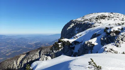
The descent goes along Mali Triglav, which is connected to its big brother with a sharp and a bit airy ridge. There are exposed sections but all of them are secured in key moments with metal railings. Difficulty - A+; this is definitely the most picturesque section of the route.
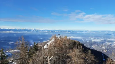
On leaving the Mali Triglav ridge we land close to the Triglavski dom na Kredarici mountain shelter. From here we can already head down back to Vrata Valley or hike to the top of Kredarica, which results in another 100m of elevation gain. Either way, we will get to the Tominškova pot and Pot čez Prag trails crossroads.
Triglav descent - Tominškova pot (B):
Tominškova pot is one of three marked paths that lead to Triglav from Vrata Valley (the other two are Pot čez Prag and Čez Plemenice). It is less vertical than the Pot čez Prag path, at least in the upper sections. It’s basically a series of secured traverses with some time to appreciate the surrounding landscape. It’s exposed slightly in two spots but technically it is really easy. Protection is there for you when needed. In the lower part it gets nastier, as the path is eroded a bit and caution is required when setting foot on the ground. It also gets steeper, which is not pleasant after a good 1,500 meters of descent. But that's the price one needs to pay for visiting Triglav.
Trip conditions
Weather:
Sunny with a considerably warm feeling for November. Still, the mild wind gusts were ice-cold, and on the top the temperature was around 0 degrees, but thanks to the sunshine it was comfortable to sit around.
Trail:
All of the trails taken during this trip are well-marked, either by red-white dots or red arrows. Paths are well-trodden, and the rock bears signs of frequent tourist traffic. The Plemenice section, which is the most demanding part, is only partly protected with metal fixtures, but the rock offers good quality and with enough care is reasonably safe to cross. Only parts below Luknja pass and lower parts of Tominškova pot are of lesser quality - the first because of scree, the second is eroded and requires more attention. There were some patches of snow on the northern side, but they were irrelevant for this trip.
Additional information
Tips and author's comments:
I had a via ferrata protection set with me and had it on, but I never used it in the end when climbing up the Plemenice section because there is not that much protection there. My personal experience was to use a single hiking pole which proved much more helpful than the actual via ferrata set; I could scramble and hike at the same time using it.
For the descent, I preferred Tominškova pot as it is a bit longer but less steep, less frequented, and also lands us closer to the parking lot in Vrata Valley.
Triglav is a sacred mountain for Slovenians, Instagram hikers, and Crown of Europe mountain collectors as well. These three make a deadly combo of extreme crowds during the season. During the summer, it is advised to avoid weekends at all costs. However, even during workdays, it would be naive to count on seclusion and an ultimate mountain experience - therefore not the full 5-star rating from my side.
I saw somewhere a reference in German to Triglav as a 'Kniebrecher' - knee breaker. There is much truth to that saying as 90% of the descent happens on rock ground with no shock absorption whatsoever that, for example, dirt ground offers. Just be warned.
Dangers:
Mostly related to overcrowding of the summit - falling rocks, jams in key moments, unprotected passages.
Gear used:
hiking poles, 20l rucksack, helmet, via ferrata set
Transportation:
Starting point reached by car. There's a parking lot just below Aljažev dom mountain hut. For more detailed information please refer to a dedicated section linked below.
Accommodation:
One can seek accommodation in many mountain huts, for example: Triglavski dom na Kredarici mountain hut, Aljažev dom mountain hut and Dom Valentina Staniča pod Triglavom mountain hut.
Links:Dom Valentina StaničaAljažev domTriglavski dom na Kredarici