Mangart
Trip overview
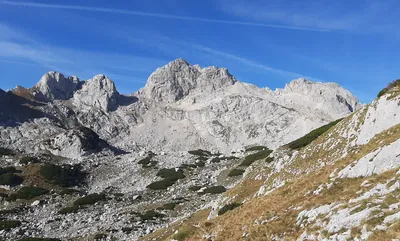
Mangart is a majestic peak of Jullian Alps, the third highest in Slovenia with 2679 meters located on Italian-Slovenian border. It is quite often visited due to the fact that it can be accessed from the parking lot located at around 2000 meters.
Mangart can be climbed using various routes and this trip aims at combining all available via ferrata trails. Yet, it comes at its price as the trip is long and costs a lot of effort.
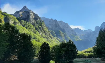
Starting from Fusine lakes main parking lot the path is almost flat but once Alpe Tamer pasture is past and dense forest is entered the steepness changes rapidly. It will continue for about 500 meters up when a rocky section is traversed with even more steepness. To enter Via Ferrata Italiana we need to go past Bivacco Fratelli Nogara and ascend another 100 meters.
Via Italiana is really interesting via ferrata with some airy moments and passage through cave. It is rated as C but there is only one place standing up to that difficulty. Securings were in good overall condition, the beginning of the ferrata is exposed to stones coming from top so attention is needed if someone is above. It takes approximately 1 hour to climb it. Once the ridge is reach the ferrata is over and the way goes south through a unpleasant path through scree that will take to the start of Via Slovenia ferrata. Taking off ferrata gear is not necessary.
Via Slovenia comes next as part of ascent to Mangart and takes us almost to the top finishing in easier terrain just around 100 meters of ascent before the summit. This B - rated ferrata can offer some traverses, chimney-like formations and ramps. It also gives a lot of loose rock and crumbliness, especially in higher sections so additional care is needed there.
Mangart offers magnificent views and is worth to rest a while considering that 1700 meters were climbed so far and 500 meters more coming if we plan to descent using Della Vita ferrata.
Start of descent from Mangart takes the normal route that heads west direction until boundary marker with hiking signpost is reached. From here the normal route goes north deeper into Italian side of the border but we continue along the ridge into western direction and after a while begin to lower on Slovenian side with grassy meandring path just to start gaining elevation just before Huda škrbina pass. Orientation at times get tricky, because stones with trail markings have either faded color or are covered by long grass. More difficult sections are secured with occasional metal wires.
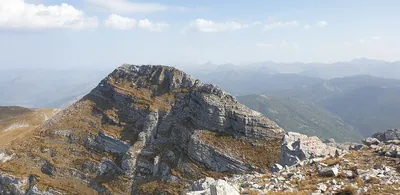
From Huda škrbina the path lowers significantly traversing southern slopes of Piccolo Mangart di Coritenza. Even so, this stretch is challenging. Orientation is at times difficult and the path lost, there is also some crumbliness and steep, grassy sections. Once in the scree falling from Forcella Sagherza pass another 200 meters of ascent is awaiting and it tastes brutally after all that effort to get here. The alternative way goes from Huda škrbina pass directly along the ridge but I was warned it is more demanding technically and having no climbing gear at all I did not venture.
Forcella Sagherza / Rob nad Zagačami pass marks the beginning of Della Vita ferrata and also offers a rest indoors in Bivacco Alberto Busettini. But the best it yet to come as Della Vita ferrata has a lot to offer. It is exposed, vertical and rich in different rock formations. It is rated as C/D and requires strong arms and steady head. Probably the crux for the ferrata is 15 or more meter high chain ladder that begins on solid rock face but with descent it ends up hanging in the air. After lowering for about 100 meters in the central part of the wall falling down from Forcella Sagherza pass the terrain eases a bit into a long to and from traverse that eventually takes as to the foot of the wall. From here down the scree to the forest and back to the lakes.
Links:Topo - Via Italiana
Trip conditions
Weather:
Sunny and partly cloudy, mild wind
Trail:
Path is marked at all times. In the valley sections are also very distinct. Around Via Slovenia the rock gets nasty, it is loose and terrain is crumbly. The ridge fragment starting at border with traverse on southern side is most challenging to navigate as the path disappears in the grass, trail marks are faded and sometimes hidden in the long grass.
Additional information
Tips and author's comments:
There are three via ferrata routes included in this trip. They have varied difficulty. Via Italiana is of C diffculty, Via Slovenia is B and Della Vita is C/D.
The GPX file included in this trip is unfortunately generic one exported from mapy.cz but for the ridge path that is demanding in terms of navigation is reliable to follow. Also the map does not show the Via Italiana ferrata chosen (it is badly drawn and the paths are not connected on the map). In other words - if you wish to enter Via Italiana ferrata don't follow the GPX file at some point.
Dangers:
Falling rocks and significant crumbliness (ferrata Via Slovenia)
Demanding navigation, steepness and exposition on the ridge between pass Mala Forca / Huda škrbina and pass Forcella Sagherza / Rob nad Zagačami. Angle of the terrain makes the trip extremely dangerous in case of wet grass that covers some parts of the path.
Condition of Della Vita ferrata - in September of 2021 the ferrata was officialy closed and it was clearly marked on entrance. The fact I decided to climb it down was a pure coincidence - I met a group of Italian climbers that used it to go up and informed me the ferrata is in renovation but secured in key moments to allow descent. Nevertheless it added the adrenaline as some parts of securings were in bad condition and some were removed completely. At the time of my trip 60% of the securings were renovated starting from the bottom. Therefore, not to get too much of adrenaline I would advise to check updates on the ferrata status.
Links:Official alpine club website - Status and info about Della Vita ferrata
Gear used:
20L rucksack, trekking poles, helmet, harness, via-ferrata set, sling, locked carabiner
Transportation:
Car driven to Fusine lakes. There is a fee for entering the lake valley in 2021 it was 4 EUR collected in August, in September free of charge.