Očnjak

Map is loading . . .
Attractiveness
Condition
Distance0 km
Duration4.5 h
Ascent0 meters
Descent0 meters
Highest point0 meters
Terrainrocky (limestone), forest
SeasonAutumn (late September 2021)
Starting pointGrebaje valley (parking lot)
Ending pointGrebaje valley (parking lot)
DifficultyI
Download gps trackHide the map
Overview

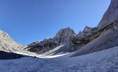
Once you enter Grebaja valley and have a clear visibility one peak will catch your sight immediately and that is Očnjak. With 2185 meters it soars about 1 km over Grebaja valley and looks reachable only using climbing gear.

In reality it can be scrambled fairly easily as the normal route has grade I of difficulty and the way to and from is roughly 6 km. Nevertheless it is demanding scramble with exposed sections.

Finding the beginning of the trail taking to the top might be tricky, walking from the parking lot get the earliest opportunity to turn left. First part of the ascent goes through the forest but there is also a bit exposed rocky traverse quite early. Once the forest is over the views open and still steep ascent up the grassy slope continues.

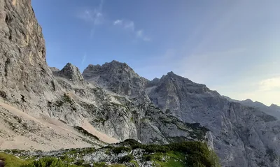
Fun begins with the third section when trail turns right to enter grassy shelves running along north face of Očnjak. Terrain has tendency to slide here and grass makes a poor hold. Two metal wires on the way. I had my shoes full of sliding ground and dirt. After about 200 meters north face is fully traversed, ascent changes direction to southern. Here the quality of the trail gets better but you will need to climb at least two chimneys and traverse a bit exposed sections. The views are already great turning into fantastic after about 15 minutes when the peak is reached.

Descent goes the same way, pay special attention when in steep grassy shelves section.

Trip conditions
Weather:

Sunny and warm temperatures, ascent started around the noon.

Trail:

Marked in red, difficult to find the start, secured in key moments but lacking securing in some mixed grassy-rocky terrain giving some trouble on descent.

General
Accommodation:

I stayed at nearby Guest house Kolata (10 EUR per night) located in Vusanje, but if you plan to stay in Grebaje valley a bit longer a good option would be to to visit mountain hut Branko Kotlajić

Links:Kollata guesthouseMountain hut „Branko Kotlajić“

Transportation:

Grebaje valley can be reached by car, on foot or hitchhiked. The nearest bus stop is in Gusinje. It's a national park therefore there's a fee of 2 EUR (not sure if for car only).

Links:Parking location

Other

3 hours is the estimated time to get to the top of Očnjak. Though short in distance this trip is a bit challenging physically but offers great views in the heart of National Park of Accursed Mountains. Personally it was warm-up trip on the first day of stay in the area.

Dangers:

Vipers (mind your steps in grassy passages), falling rocks, exposed sections.

Gear used:

Helmet, 20L rucksack, trekking poles, 10m of 7mm cord

Visual
Loading image . . .
Closing in on Grebaje Valley. In distance local peaks can be seen, including Očnjak marked by *
Loading image . . .
In Grebaje valley, I did not mark Očnjak, the sun did!
Loading image . . .
Number of trails resembles more of Alps than allegedly wild and unsurmountable Accursed Moountians. 3 hours till top starts now.
Loading image . . .
Not that trivial rocky traverse after about 30 minutes from the start. Still in the foreset afterwards.
Loading image . . .
Above the forest and up through alpine meadow zigzags we approach north eastern slopes of Očnjak.
Loading image . . .
Start of mixed grassy-rock shelves. Terrain starts to get nasty at times, put on your helmets and extra caution.
Loading image . . .
Down below Grebaje valley. In the foreground securings on the western side of the mountain where the trail turns south. Terrain is firm but there is a bit of climb in here. These wires are not that convenient - they are covered with gum which overly attaches to the hold and what is even more annoying - these wires are not tight to the wall. I mean they are firm but given a hold they allow a slight tilt which does not help you keep balance.
Loading image . . .
View from the top into southern direction. The dominant summit with massive face and underlying patch of snow is Veliki Vrch. Also in distance, marked with * Maja e Jezercës is visible, the highest peak of Accursed Mountains.