Antelao
Trip overview
Antelao - is the second highest mountain in Dolomites and is sometimes referred as the king of this range. It's a mighty rocky piramide that catches eye from many neighbouring peaks. It's also pretty challening. It's one of the 3-thousanderes that does not offer via-ferrata path to its top. There are exposed sections, huge deal of ascent, significant risk of rockfall and the trip relies heavily on terrain and weather conditions. For some it may sound like a perfect trip and indeed it is.
Path starts form Praciadelan parking lot, firstly it tries to find it's way around dried riverbed of the D'Oten valley to finally hit some wooden slopes just after Capanna Degli Alpini mountain hut. The steepness is pleasant and the path nicely marked, after gaining some elevation and crossing the dry riverbed again more ascent begins in dwarf pine terrain. After some time we arrive at Galassi mountain hut. From here just half an hour more to the Forcella Piccola mountain pass.
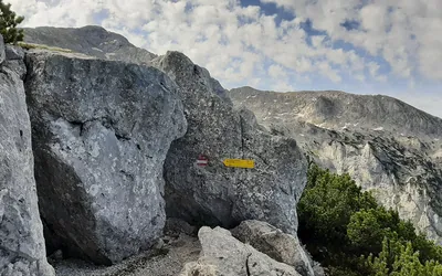
Start of the via normale to Antelao: from Forcella Pass there is theoretically no trail but there are some marked spots that will help to find the way and of course the path is distinct enough to follow it. We hit southern direction and ascend moderately in the limestone realm, grassy at first and then entering rocky basin walking on scree material on its left side. We get to the point where slabs block walking and this is the start of the real thing. Following the markings we climb up a serie of exposed grassy and stony ledges on the eastern side at first and then crossing to the western side. This part is quite crumbly and the upper sections lead along the ones below, so keep that in mind in case there are other people above or below. When going in a group try to keep close to mitigate the risk of falling rocks. Climbing difficulties don't exceed I grade.
Next we land just at the foot of so called 'laste' - a great slide like pillar stretching to the main formation of the summit. In here the rule is to keep to the left side and again the biggest danger in case of good weather conditions is rock fall from people ahead. Rocks are reaching sonic speed here being rolled from the top, you don't want to stand in their way. This section is dependent on humidity conditions. If covered in ice or being wet the best choice is to turn back and head down. Any problems with slipping on ascent mean extreme problems while going down. It is also relatively long.
'Laste' ends at about 3050 meters above sea level and now there is some climbing to be done. At first a II chimney, a bit of traverse and then exposed ledge with a secured chimney and couple of more ledges. They are not that difficult if they are dry.
Summit of Antelao lies at 3264 meters and is interestingly split between two culminations. It (probably) offers fantastic view (mine was fantastic but only in northern direction where there were no clouds). Anyway after all theses hardships you may find yourself worthy of the King.
Descent is definetely the hardest part of the trip. The climbing part of the last 200 meters requires constant attention. In 'laste' we must focus not to step on the rocks in order not to slip and to cause danger to others and this section drags endlessly (from the knee perspective). Finally in the grassy ledges part - the orientation gets a bit tricky and also we need to watch for our steps, as the ledges are sometimes exposed and full of rocks. At this point it is worth to mention that this part will be descended around 9 - 10 hour from the start so exhaustion may be creeping around. If you plan to conquer Antelao without a night at the Galassi hut make sure you are prepared physically and mentally for that challenge !
Trip conditions
Weather:
Warm to hot while in the sun, once clouded mild to cool temperatures. No wind.
Trail:
All the way to the Forcella Piccola pass is marked and the path is descent. Via normale to Antelao is not an official trail but path is marked in places and the marking is good enough, also the path can be recognized. Extra caution required just before the summit in the scrambling section where other variants seem as the correct but may be more difficult.
Additional information
Tips and author's comments:
The water is scarce on the way, there is one stream just below Galassi hut. In the hut there is no drinking water, of course the bottled one can be bought that is 2 EUR for 0.5l and 3 EUR for 1l. Once a member of mountain club (like DAV, OEAV) 25% discount applies
If you plan to have a dinner at the Galassi mountain hut try to let them know in the morning on the way up. When we came there in the afternoon we got only served with some snacks. Pretty delicious though.
Dangers:
Falling stones, exposed sections, risk of slippering, orientation problems if clouded, physical exhaustion.
Gear used:
20L rucksack, trekking poles, helmet, 10m cord,
Transportation:
Car driven to parking lot in Praciadelan site above Calalzo di Cadore. Road is in decent state, tha parking lot still ofered some free spaces.
Links:Parking lot
Accommodation:
Galassi mountain hut is the closest one with alpine character, warm people and lovely service. There is also Capanna Degli Alpini refuge in the D'Ota valley that is really quite low but located in desolated and tranquil D'Oten valley.