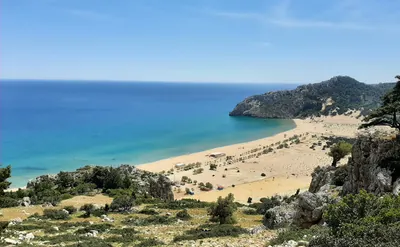
Kokkini Ammos beach

Map is loading . . .
Attractiveness
Condition
Distance0 km
Duration2 h
Ascent0 meters
Descent0 meters
Highest point0 meters
Terrainrocky (limestone)
SeasonSpring (late April 2023)
Starting pointAgathi Beach - parking lot
Ending pointAgathi Beach - parking lot
DifficultyI
Download gps trackHide the map
Overview

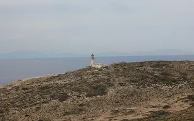
Short hiking trip to Kokkini Ammos beach located close to Agathi beach in Archangelos district. Both of these beaches are one of the finest on the island of Rhodes. Red sand beach is located about 2.5 kilometers but the terrain makes it difficult to cover that distance fast.

Starting from Agathi beach parking we head north and go above Saint Agatha's cave, then follow a rural, red clay road that takes us to the coastline. Now we traverse the rocky shore around 50 meters above the sea level. At some point the passage widens and the trail starts to get farther away from the coastline. That's the moment when we leave the trail and approach the cliff. The beach can be already seen and we need to get to the left side of it, there is the most approachable descent option - that is near the rock with painted Greek flag.

First 7 meters of descent (I climbing grade) may look serious from the top but there is a fixed rope and good holds - using the rope is actually not necessary. Yet caution is needed as the the rock has a slippery surface. After this section we find the path and continue descent to the beach with ease.

Return path goes exactly the same way.

Trip conditions
Weather:

Warm to hot when wind died off and rocks reflected sunlight.

Trail:

Well marked with red and blue dots and arrows. Path goes through nasty terrain at times and is a bit demanding to walk. Descent to the beach is secured with fixed rope.

General
Accommodation:

Stayed in Tranquil Cottage House, that's 15 min of car drive to the Agathi beach.

Links:Accomodation I used during Rhodes stay

Transportation:

Starting point reached by car.

Links:Parking location

Other

This beach is generally out of the range for most of the tourists and you will likely share it with few people only or maybe even just yourself (and probably the goats that are frequent visitors).

Dangers:

Difficult terrain to walk, some caution needed on climbing down and up the beach.

Gear used:

Trekking poles

Visual
Loading image . . .
On the map the trail marking is yellow, in reality you need to follow red dots. This is the easier and more enjoyable part.
Loading image . . .
Seeing the hole in the rock means that now terrain will get nastier.
Loading image . . .
Trail section with narrower and tougher terrain. But landscape is still charming.
Loading image . . .
Kokkini ammos - that translates to red sand in English. In reality instead of the sand we get to walk on the gravel but that doesn't change the marvelous impression looking at the beach from the top.
Loading image . . .
Descent path to the beach with visible fixed rope where the route goes. Looks tougher than it really is.
Loading image . . .
At the beach, looking into eastern direction (beach left border). Greek flag marks the sport where descent is and the rock on the top makes a navigation point when leaving the trail. Because of its remoteness beach is most easily reached in a boat and these could be expected to appear with some tourists. Other than that there were some goats roaming around.