Cima Alta di Riobianco - Spigolo Nord Integrale
Trip overview
Cima Alta di Riobianco (Visoka Bela Špica) rises in the Italian Julian Alps to about 2257m and is known for its compact limestone walls above the Riobianco valley. It offers many classic climbs in perfect rock and in a beautiful ambience.
Spigolo Nord Integrale (-V) is a variant of the first attempt to climb the north pillar - Spigolo Nord Originale. It's longer and more challenging. The route covers 300m and has 9 pitches. In the lower part, the rock could be a bit better; in the upper part, it is perfect. The route is not to be underestimated; in the lower part, the orientation is not so obvious. There are also two variants of the second pitch (both rated as -V). The route is equipped with bolts and pitons, with bolts only at belays. Additional protection is necessary. The route is also significantly exposed, which increases the mental load. Since it's a classic one in the area, it is very popular, and probably during summer weekends it will be crowded, especially since the CAI Gorizia shelter is located practically at the foot of the route.
Route description
Spigolo Nord Integrale (-V) general information:
| Access time | 2h 00m |
|---|---|
| Descent time | 2h 30m |
| Climbing time | 6h 00m |
| Length | 360 meters |
| Pitches | 9 |
| Difficulty | -V |
| Rock type | limestone |
| Wall orientation | NE |
| Protection | alpine |
Spigolo Nord Integrale (-V) access:
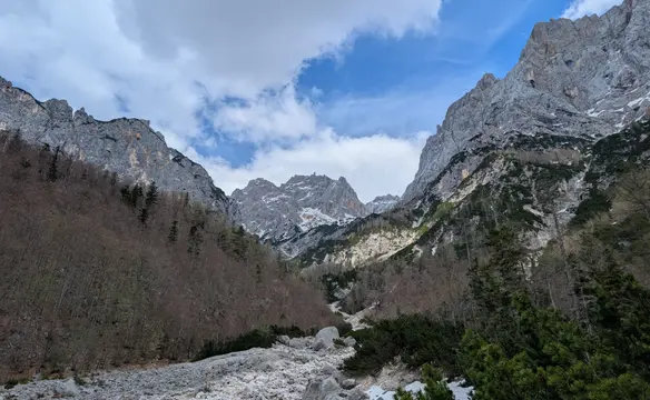
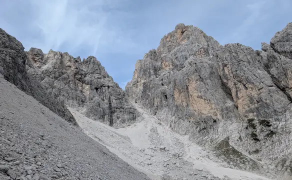
Starting from the Rio Bianco parking lot we take trail no. 625 and head for the Capanna Brunner lodge. Next, we continue on that trail, finally heading more in a westerly direction, and land below the C.A.I. Gorizia bivouac. From here, head towards the wall, then follow a well-trodden path to the left (there are even red paint marks). Go a short way down the grass, then up the scree to the easy rocks - enter from the left. Climb grade II terrain to the first belay, located roughly in the middle of these rocks, just before the wall steepens.
Spigolo Nord Integrale (-V) route description:
- IV (2 pitons, maillon, 45 m). The start is a bit loose - climb diagonally right up a corner under the pillar (piton), then straight up the corner (another piton). After reaching 3 pitons and a sling, move right into the corner - do not go straight up. Follow the corner onto an easier slab and up to the belay.
- V- (2 bolts, 50 m). From the belay, go diagonally left across the slab, bypassing the overhang (old piton, sling in a rock thread), then diagonally right under the roof towards a visible crack (piton on the right when standing below the crack). Go up through the crack (V-, place your right foot deep inside), then left again (piton to the left of the crack) onto a ledge (good placement for a cam). Follow the crack up the small wall (piton on the left hidden behind a jug), and up another crack (rusty piton) to a comfortable belay.
- IV (bolt and a sling in a rock thread, 40 m). From the belay, go left and up, initially through an easy (II) and later harder corner (piton on the left - watch out for rope drag). Below the steepening of the rocks, move right to a small chimney that is already visible from the belay (2 pitons below the chimney, 1 piton inside). After exiting onto a ledge, keep to the left of the prominent chimney to reach the belay. Note: I'm not entirely sure about this pitch; the right-hand variation shown in the topo is probably better and might make it easier to find the bolted belay. In that case, the next pitch is unnecessary, and you exit via the prominent chimney mentioned earlier.
- IV (2 pitons, 25 m). Start via footholds on the left (an easier exit to bypass the block at the belay station), then go diagonally up and right under the steepening until you reach a chimney cutting through the wall (piton). Next, cross the chimney and continue right (piton) to a distinct ledge on the pillar (belay).
- IV+ (2 bolts, 50 m). First, climb straight up on good rock with distinct holds (rock threads) to the base of a vertical, 12-meter corner (yellow rock on its left side). There is a piton under the corner. Then, climb straight up the corner (good holds and footholds); at 5 meters, there is a piton on the left (there is a rest spot). Continue up its left side (you can still rest). After exiting, move a bit more to the left - good holds. Then move to the next corner (III) and climb it (no pitons).
- III (2 bolts, 40 m). From the belay, go straight up between the main wall and a small pinnacle among rock blocks, then right (after 5 m there is a belay for another route - DO NOT use it) and diagonally back to the pillar (placements for slings) to a belay with 2 pitons. From here, go right of the pillar via easy terrain to a belay with 2 bolts.
- III+ (2 bolts, 50 m). Climb up on good rock via a crack to the right of the belay, initially in the center (pitons), and higher up closer to the pillar (good holds). Where it steepens, move right onto a wide grassy ledge. Then head vertically towards a small crack (new piton). Above, climb on good holds with some exposure to a belay on a wide ledge with a memorial plaque.
- IV+ (III) (2 bolts, 45 m). From the belay, go left across a slab (piton), then up a corner in excellent, dark-yellow rock (good holds, cam placement, piton) to the final belay (2 bolts). The difficulties can be bypassed via a grade III variation on the right, which leads to the same belay.
- II (2 bolts). Go right up a loose, small gully to the summit, or left over a small pinnacle. At the summit, there is a sling around a block for belaying.
Links:Topo of the routeRoutes overview (Quarto Grado) - no. 24.2
Spigolo Nord Integrale route exit (III):
Head down the south side via loose paths (marked with cairns), then turn east to the edge of a deep couloir. You now have about 90 m of rappelling (abseiling). The first rappel sling is on a rock block - the next one is after 30 m (two bolts), and the last one is again on a rock spike/horn. Rappel down to the Forcella Alta di Riobianco pass, from where you follow the trail back to the CAI Gorizia bivouac (loose rock, steep, watch out for falling stones!).
Trip conditions
Weather:
Sunny with moderate temperatures. The route is partly in the shade (lower parts in the morning), with the exposed part in the afternoon. It can get hot in summer.
Trail:
Access to the route presents no difficulties; paths are well-marked and trodden.
Additional information
Tips and author's comments:
The route maintains a rather consistent difficulty and requires a good eye for recognizing its flow. Due to its popularity the pitons are placed outside the route, being deceptive. According to the guide it takes 4 hours to complete the route, for us the case was more than 6 hours actually.
The Riobianco valley holds a lot of climbing classics in the Italian Julian Alps; literally every peak around has a must-have climbing route. These include:
- Direttissima (+IV) - Cima delle Cenge (2.007m)
- Rampa Mediane (IV) - Vetta Bella (2.049m)
- Piemontese-Ive (+IV) - Cima Piccola della Scala (2.101m)
Dangers:
The risk of rockfall from teams above us is not very high; however, it can't be ruled out. Rock quality gets better with altitude. From the third pitch onwards, the exposure kicks in really strong.
Gear used:
20l rucksack, hiking poles, approach shoes, climbing shoes, harness, helmet, personal climbing set, 2x60m ropes, 12 quickdraws, set of cams (0.5-2), set of nuts, 8x 120cm slings, prusik, knife
Transportation:
The starting point can be reached by car. There is a large parking lot available 100 meters from the start of the trail; there's a fee, and the price is 8 EUR per day. However, there are also numerous options on both sides of road 76 if you arrive in the early morning.
Accommodation:
The area offers quite an abundant choice of overnight stays to shorten the access to the route. First, there is the Capanna Brunner hunting lodge, which is located quite close to the start of the trail. However, for the stay, we need to get the key from the CAI Tarvisio alpine club. This option shortens the access by only 1 hour, but the main advantage is the running water outside.
The other two options are the CAI Gorizia shelter and the Ricovero Riobianco shelter. These are located next to each other, literally at the foot of Cima Alta di Riobianco. Access from here is around 5 minutes. There is also no hassle of getting a key from anyone. The downside is that there is no water available.
Links:Capanna Brunner locationAccessing Capanna BrunnerCAI Gorizia shelter locationRicovero Riobianco location