Veunza (Della Vita, Kugy via ferrata)
Route scheme
Trip overview
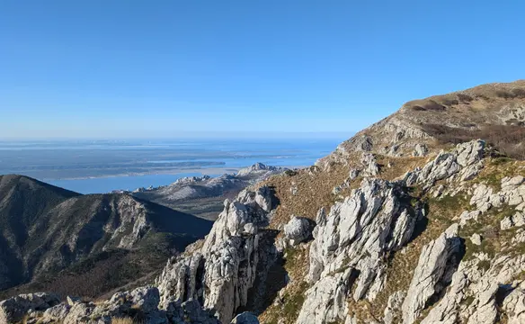
Cima della Veunza, also known as Vevnica in Slovenian, is a 2.340-meter mountain peak situated on the border between Italy and Slovenia within the Julian Alps. The mountain is known for hosting the "Via della Vita," which is considered one of the steepest and most challenging via ferratas in the entire region. Summit offers panoramic views that overlook the picturesque Fusine Lakes on the Italian side and the deeply carved Tamar Valley in Slovenia.
In this trip we will be climbing Veunza using the above-mentioned della Vita via ferrata. After reaching the top we will continue along the ridge in the direction of Ponza Grande peak using the famous Via degli Alpini route and descend from the pass below Cima Strugova using the Kugy via ferrata.
The Via della Vita (Path of Life) is a demanding via ferrata that ascends the northern face of Cima della Veunza in the Julian Alps. Characterized by continuous vertical sections and significant exposure, the route utilizes fixed cables, metal pegs, and ladders. Due to its exposed nature and technical difficulty, it is considered one of the most challenging equipped routes in the region. Whole route was renovated in 2022, all the protection is shiny and brand new.
The Via degli Alpini is a historically significant equipped mountain trail in the Julian Alps that runs from Ponza Grande (Visoka Ponca) to Alberto Busetti shelter. Originally established by Italian mountain troops (Alpini) to secure and patrol the high-altitude border, the route features a rugged combination of cabled sections, narrow ledges, and rocky scrambles. Today, it operates as a classic via ferrata that offers climbers a moderately difficult ascent or serves as a scenic connecting ridge route for those traversing the peaks above the Fusine Lakes.
The Via Ferrata Julius Kugy (often referred to as Sentiero Attrezzato Kugy) is a classic equipped mountain route in the Julian Alps dedicated to the alpinist and writer who explored and popularized the region. Just as the other two, it was used by the Italian soldiers during the First World War. It is considered to be of moderate difficulty. It's also been renovated in 2024, all the protection is shiny and brand new.
Route description
Via della Vita via ferrata - access description:
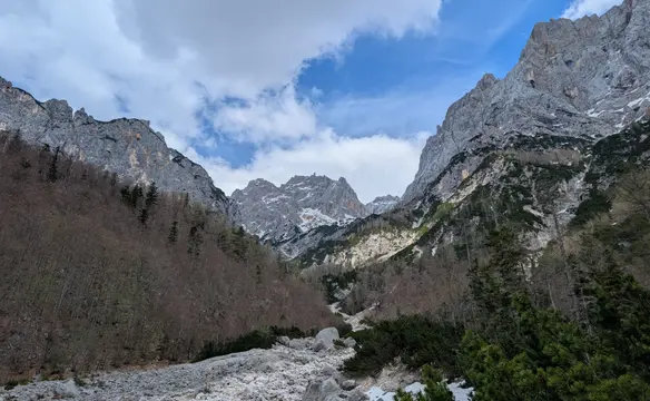
Starting from the big parking lot above the Fusine lakes we take the 512, then 513 and finally 513a trail to get to the start of the via ferrata. The trail is well marked and easy to follow. After getting closer to the high walls surrounding the valley the terrain gets nastier and we will need to climb up in the scree. There is also one secured moment to be crossed. The final 200 meters of climb to the start of the ferrata are monotonous; however, the surroundings are stunning.
Via della Vita via ferrata (D) description:
Via della Vita via ferrata starts at around 1.800 meters, covers 250 meters of elevation gain and takes around 90 minutes to complete. The entrance is on the left side of the cirque hidden behind a big rock. We climb up wide chimney (metal steps, B/C) to land on the exposed ledge. We will follow it traversing the wall (A/B) and at some point climb again and change the direction, all the time in significant exposition. When it eases off we cross more ledges with crumbly material (B) to finally get closer to the giant dihedral in the wall. Here we cross it to the other side, climb up using the available chain and we face the hardest part of the ferrata. Now using metal steps we climb up the wall vertically in growing exposition (C/D), traverse to the right and once again climb up using ladder-like aids sticking out of the wall or inside small dihedral (D). Eventually the direction changes to the left and we reach the ledge above the wall. Now more to the left (don't follow old red markings to the right - protection is removed!) and take the path up in the direction of Sella Veunza pass. Via della Vita ferrata runs as far as Bivacco Alberto Busettini shelter but we do not turn right now and switch to Via degli Alpini route.
Links:Via ferrata status
Veunza (2.341m) from Sella Veunza pass to Cima Strugova (2.265m) (Via degli Alpini):
Once on Sella Veunza pass the peak of Veunza is really near - around 15 minutes. We now walk on the ridge that separates Italy and Slovenia. The ridge requires attention, it is protected in key sections however there is also exposition and poor rock quality. From the peak of Veunza we continue in the direction of Cima Strugova. At first the terrain is even but once we cross one of the Veunza subridges there is a significant drop in altitude and lots of downclimbing awaits us. Terrain is crumbly and the condition of the protection is deplorable here. I would say in a couple of spots it's risky to use. Also in some places it is missing - either the bolts are out or the cable is broken. Still the path is passable and the vertical sections where additional help and protection is absolutely necessary to cross are in okayish condition. The aids are even more sparse than in Via della Vita ferrata and for me personally that section was more demanding technically (D). After the downclimb, we get back to the main ridge and now we navigate the ridge with the help of the cables in key moments. Watch out for the markings (red dots, sometimes cairns), the path is not that obvious to follow, it does not run exactly on the ridge. Getting to Cima Strugova took us 2 hours from Veunza. Without snow on the path it could probably be done at least 15 minutes faster.
Via ferrata Kugy (C) - description in descent from Cima Strugova (2.265m):
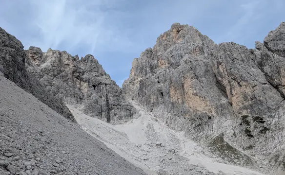
Via ferrata Kugy starts at the altitude of around 2.170 meters and covers 500 meters of elevation difference, finishing at 1750 meters. In descent it takes around 75 minutes to complete. It runs on the northern slopes of Cima Strugova either diagonally or directly down. Direct sections are more difficult (C), the diagonal ones are easier (A-B). Metal cable is the only protection on the route, except maybe for two spots where some steps have been added. Exposition is rather limited and more present in the lower part of the route. Rock is generally of decent quality, however there are also two sections where we cross crumbly terrain. Protection is in excellent condition - it has been renewed in 2022. One spot where the cable is misplaced due to rockfall is not an issue as it is walking terrain.
To get to Kugy via ferrata we need to descend from Cima Strugova in the direction of Ponza Grande. Just before Sella Strugova pass we leave Via Degli Alpini route turning left. Now we just follow the cable which runs along 95% of the route so orientation is not an issue.
Links:Via ferrata status
Via ferrata Kugy (C) - exit description in descent:
Via ferrata Kugy exits at 1.750m of altitude descending from rocky blocks into scree at the top of the cirque. In May it was completely covered in snow, and there might still be some snowfields left later in the summer. From here, head down the scree keeping on the right side (when descending) of the cirque along marked trail 513c. The path is not that distinct, however, it is recognizable and easy to follow. Upon reaching the 513 trail, to get back to the parking we can either turn left back on the trail that we took when going up to Della Vita via ferrata (longer) or turn right and head down passing Luigi Zacchi hut (shorter but around 30 meters of ascent first).
Trip conditions
Weather:
Sunny in the morning, clouded in the afternoon. Moderate wind on the ridge did not allow to wear only one layer, 10 degrees in the morning.
Trail:
Please refer to dangers section.
Additional information
Tips and author's comments:
That was my second time on della Vita via ferrata, last time I did it in descent and before renovation. I am happy to see new protection but it seems like it has changed its character a bit. The 10 meter airy metal ladder that was dangling from overhang in the vertical section is sadly gone. I think it has been replaced by a series of metal steps. Still, the ferrata is one of its kind and definitely worth a visit. The ambience is unique.
Kugy via ferrata didn't make the same impression as Della Vita, it felt more like a commuting route, which is what it ultimately was in the past for Italian troops. Some parts in descent were even annoying as the cable is running in the middle of the path and to clip in I needed to bend down (and I am not a tall guy). In some spots the cable runs along bare rock with no help for the steps which seems illogical taking the terrain into account - like making it deliberately more difficult. Personally - good only in combination with other routes in the area.
Via Degli Alpini is a classic, but it's not for everyone. The condition of the protection is deplorable in some sections, and the rock quality is poor. It's a route that requires a lot of attention, off-route experience and a bit of scrambling skills. It's a good option for those who want to experience a historical route, but it's not a route to be underestimated.
I climbed down Della Vita via ferrata while descending from Mangart and the route is described in the post linked below.
Links:Climbing Mangart
Dangers:
Dangers present in this trip make it a risky one. It is definitely not suitable as first step into via ferrata realm. Also, for people more experienced with via ferrata it is worth to note that Via degli Alpini route is not a classical via ferrata. Lots of spots on the ridge are exposed and protection is not always present. Key dangers:
- exposition (Della Vita via ferrata, Via degli Alpini route)
- poor rock quality (sections of Via degli Alpini)
- rockfall (Via degli Alpini, Kugy via ferrata)
- deplorable condition of protection cables (Via Degli Alpini)
- orientation problems (Via Degli Alpini)
Gear used:
35l rucksack, hiking poles, via ferrata set, helmet, climbing harness, crampons, ice axe, resting loop, 30m rope, 3x 120cm slings
Transportation:
Starting point reached by car. There is a parking fee of 6 EUR if arriving between 8 and 19. The parking lot is big and can accommodate many cars.
Links:Parking location