South Velebit hike-thru
Trip overview
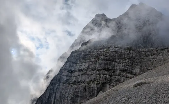
The Velebit mountains are the largest mountain range in Croatia, forming a natural barrier between the Adriatic coast and the continental Lika region. As a recognized UNESCO biosphere reserve, this rugged segment of the Dinaric Alps is celebrated for its dramatic karst topography, deep cave systems, and rich biodiversity. The South Velebit section features the most prominent alpine terrain of the entire range, hosting its highest summits, including Vaganski Vrh and Sveto Brdo. This area is also home to Paklenica National Park, a golden destination for hikers and rock climbers drawn to its spectacular, deep-cut limestone canyons.
This hike doesn't cross the whole South Velebit section because the stages from Sveto Brdo peak to Crnopac are omitted. However it covers the highest peaks of the range and the most scenic parts of the Via Dinarica trail. It's a challenging route, but the views, mountain experience and seclusion are unique and truly difficult to find today.
Route description
Detailed route description can be found in each of the "Day" sub-pages above the map.
Trip conditions
Weather:
End of October/start of November temperatures ranged from 23 C to below zero. Personally for me that was a sweet spot for this hike, can't imagine doing it in the summer heat. Obviously the coldest part was the one with the highest altitude, waking up to frost-bitten ground in Struge shelter was something surprising.
There are quite noticeable temperature changes while crossing the ridge between maritime and inland sides. That was the case for November, probably in warmer parts of the year being on the inland side would be more pleasant.
Watch out for wind speed numbers in the weather forecast. Since Velebit lies close to the coast it’s a place where coastal and maritime air meets resulting in extreme winds (jebena bura!).
Trail:
The terrain is relatively difficult to walk because of the limestone formation. Pretty often the path meanders around the rocks, is uneven, rugged etc. The map distance seems short but requires more time to cover because of that. For example - 14km is estimated for 6-7h of walking time.
Trails taken in the provided route (and gpx file) were all well marked, distinct and passable - that refers to mostly going along the Via Dinarica trail. That can’t be said about side trails that join the main one. In a couple of cases at such crossroads it was obvious that no one used them for a long time.
Links:Hiking signpost timesVelebit forest terrainVelebit alpine terrainVelebit typical landscape
Additional information
Tips and author's comments:
As in the last couple of years my mountainous interest shifted towards more adrenaline-provoking activities I never forgot where I came from. Sadly I don't have enough time to do a lot of thru-hikes now and this was my first one in something like 10 years. Felt a bit stressed out mostly due to the fact I was hiking with a 9-year-old kid. I can honestly say that this route has exceeded my expectations. The area of Velebit is pristine and trails are not overcrowded, you can really count on seclusion in here. Huts are placed so that the hike can be easily split into convenient sections, plus they contain everything you need. The terrain is really diverse with stretches resembling more Velka Fatra or Mala Fatra mountain ranges in Slovakia for example and also more typical Croatian coastal landscapes - not to mention plains stretching at the foot of the mountains. Diverse terrain means also varied views and in here the combination is truly outstanding, seeing limestone peaks with the sea and islands in the background.
Dangers:
Velebit mountains just like all other Dinaric mountains are notorious for poisonous snakes - horned nosed vipers (poskok in Croatian). Watch out, mind your steps in grassy passages. Long trousers are an option - if you can stand the heat wearing them. From personal experience I can say that I never met these snakes above 1,000 meters of height.
Mobile signal - more than 80% of the trail has it available and also most of the huts are reachable via phone, internet is of LTE speed pretty often. The problem arises in case of terrain depression which is quite specific for limestone formation. These are guaranteed to be devoid of mobile signal. Take that into account while hiking alone as calling for help might be tricky - always inform someone upfront about your planned route.
Gear used:
hiking poles, 60+10l rucksack, down sleeping bag, water filter, sleeping pad, cooking stove, replacement gas catridge
Transportation:
The area of Velebit was reached by a car which was parked in Karlobag. From there we took a bus to Seline. The travel time is around 1 hour. I bought the tickets while getting on the bus, turned out to be cheaper than booking it online. It might be risky in higher season and there might be no vacant seats.
Public transport along the coast is not that frequent. There is no bus connection from Baške Oštarije. It worked better for us to buy the ticket directly from the driver, was cheaper than booking online - but only cash is accepted. You can also look for taxi or shuttle services, these stickers were all over the bus stops in Karlobag. The last option is hitchhiking.
Accommodation:
Mountain huts are well prepared and equipped. They are quite popular among locals. Only in Ivine Vodice had we no other tourists inside. Of course ear plugs are always advised as Croats are lively people who enjoy cherishing life. Mice are a common thing in the huts judging by the crap they leave. Always keep your food in a bag hanging on the wall - there are often dedicated nails for that.
Provisions:
Water is available only in the wells located next to the mountain huts - with one exception for Stražbenica spring which provided a fantastic feeling of washing in running water.
There is no spot on the way that would allow to re-supply the food therefore all of it has to be carried from the start.
Trip photos
Other trips to check
Velika Martuljška Ponca
Mountaineering in Julian AlpsSlovenia
Cima del Vallone via Sentiero del Centenario
Scrambling/Via Ferrata in Julian AlpsItaly
Vetta Bella - Rampa Mediane
Mountaineering in Julian AlpsItaly