Gerlachovsky štít via Martin's route
Route scheme
Trip overview
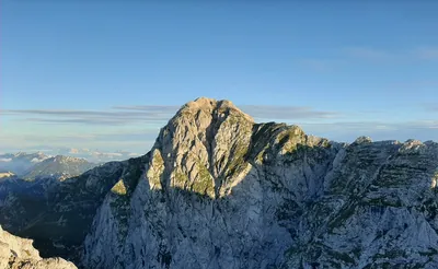
Gerlachovsky štít as the highest peak in Tatra mountains and in Slovakia belongs to the Great Crown of High Tatras, Crown of Europe and what not. Because of that it's an object of desire for many of mountaineers. There are multiple ways to climb it but the Martin's route is arguably the best and most attractive of them, at least when we speak about routes of touristic nature. Route takes normally around five hours to complete and that was the case for me - that included 2 abseils, one pause to eat and hundred little ones to take some pictures.
Starting from Tatranske Zruby follow the blue, yellow and green trail all the way to the Slezski Dom mountain shelter at the mouth of Velicka valley. Then continue up the valley still on green trail up north till you reach Poľský hrebeň pass (2200 meters above sea level, last sections are secured with chains and metal ladder steps). It takes approximately 3 hours from the start.
Velický štít (2320m and 45 minutes from Poľský hrebeň pass) is the first prominent peak on the Martin route and it takes about 1 hour to get here from Poľský hrebeň pass. On the way couple of culminations are crossed, terrain is mixed ridge with grass, rock is of decent quality and difficulties don't exceed I grade. Only problematic spot could be the descent as there are steep slabs in the ridge direction. They could be bypassed descending south but the safest option is to use the abseiling point available in here. 10 meters of abseil is good enough to be placed in safe terrain. Then we continue along the ridge to Velické sedlo pass (30 minutes).
Litvorový štít (2421m) is another prominent peak on the path, from Velické sedlo pass it is 30 minutes. Ridge gets more rocky here but difficulties are around I grade or less. From the peak it is 10 minutes to Litvorové sedlo pass.
Litvorové sedlo pass can be a starting point for limited version of Martin's route. It seems to be more popular with mountain guides leading their customers (met 2 teams like that). From here the trip gets more serious in terms of difficulties, exposition and altitude. It is also more problematic to retreat in case of bad weather conditions or exhaustion. Therefore take these factors into account before venturing further upon.
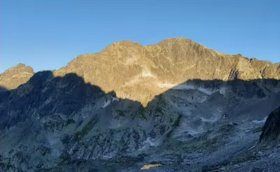
The overall time to reach Zadný Gerlach (2617m) being the highest point in given stretch is about 3 hours from Litvorové sedlo pass. It takes to climb and descend multiple culminations but the general trend will result in increase of the altitude. This section requires surefootedness and adaptaion to exposition as it comes in plenty in here. I counted about three II degree climbing sections - these are short but combined with exposition are really exciting and sometimes cross safety/risk ratio, there is also one exposed traverse which can be by-passed on the western side of the ridge. The rule here is to follow the most approachable option - and clues for that can be found on the rock itself (like scratches from crampons), most of the by-passes go on the side of Velicka valley. Therefore having clear visibility is the key element for the first time goers.
Gerlachovské sedlo separates Gerlachovsky štít (2655m) from Zadný Gerlach (2617m) and to get to it from the latter 15 minutes is needed in rather easy terrain. From the pass it is about 20 minutes of steep and airy climb (but with good holds and steps, also of good quality rock) to the flattening of the ridge and then after another 15 minutes the peak of Gerlachovsky štít is reached. This section is rated II but I would rate it I/I+ as it seems easier than previous sections. Congratulations, that's it !
The normal descent route goes through Batizovský žľab gully. The path is more unpleasant than technically difficult but nevertheless attetion needs to paid. One section is secured with metal ladder steps and metal aids. After the gully is left we continue down in direction of Batizovske pleso lake. Once on red trail continue back to Slezsky Dom hotel and use the marked trails to get back to Tatranske Zruby parking.
The route presented in the map (taken in the gpx file) goes through Dromedárov chrbát but not precisely as I lost the exact path because of the weather. Difficulties do not exceed I grade but the path is nasty and to get through the forest of bog pine one need to navigate on large stones that eventually take to the red trail mentioned in paragraph above.
Trip conditions
Weather:
Cold at dawn (about 7 degrees), to 10 degrees on the top of the ridge, thanks to the sun it was felt as warmer. Clouded from the noon.
Trail:
Marked path of the trail is in excellent condition, well marked and secured. Off-trail path that goes along the ridge is obvious enough, though different variants are available. Rock quality is really good, crumbliness is rather an exception.
Additional information
Tips and author's comments:
Trip can be shortened by starting from Litovore sedlo pass omitting Litvorový and Velicky štít.
I used the rope twice, once to abseil from Velický štít and then on the small pass before Zadný Gerlach (2617m) there is a steep slab, rope will add a key hold in here.
Dangers:
Very exposed ridge sections.
Difficulties may turn out to be higher than described depending on chosen path variant.
Considerable effort to climb the whole ridge with limited options to retreat in upper sections with long and not always easy descents.
Gear used:
20L rucksack, trekking poles, helmet, locked carabiner, sling, 30m rope, personal climbing set
Transportation:
Car driven to Tatranské Zruby, there is a possibility to leave the car free of charge.
Links:Parking lot location